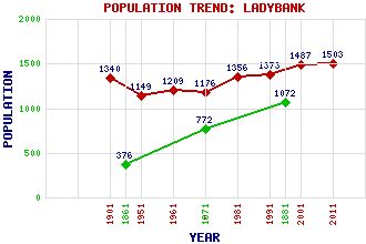
Ladybank Classification and Statistics Settlement Type: village Population (2011): 1503 (2001): 1487 (1991): 1373 (1981): 1356 (1971): 1176 (1961): 1209 (1951): 1149 (1901): 1340(Police Burgh) (1881): 1072 (1871): 772 (1861): 376 Tourist Rating: No Text of Entry Updated: 03-AUG-2017 Location Latitude: 56.2764°N Longitude: 3.1255°W National Grid Reference: NO 304 099 A range of modern and historical maps are accessible through the map tab on the right of this page Get directions by entering the UK postcode of your location, home or hotel here eg. EH1 3YT Use the tabs on the right of this page to see other parts of this entry Related Entries There are 26 related entries. (2 Attractions, 1 Council Area, 1 Historical County, 10 Features, 1 Parish, 1 Person and 10 Settlements) Names that are not linked do not currently contain any information. Attractions: Lindores Abbey Melville House Doocot Council Area: Fife Features: East Coast Main Line Eden, River Edensmuir Forest Hilton Junction Howe of Fife Kirkcaldy Railway Station Ladybank Golf Course Ladybank Railway Station Melville House Rossie Drain Historical Counties: Fife Parishes: Collessie People: William Briggs Settlements: Annsmuir Bridge of Earn Craigend Crossgates Cupar Giffordtown Luthrie Parbroath Ramornie Rankeilour
There are 26 related entries. (2 Attractions, 1 Council Area, 1 Historical County, 10 Features, 1 Parish, 1 Person and 10 Settlements)
Names that are not linked do not currently contain any information.
By using our site you agree to accept cookies, which help us serve you better