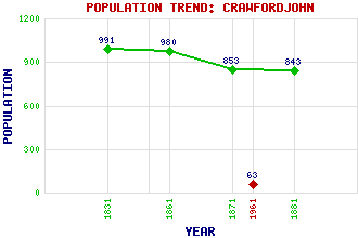
Crawfordjohn Classification and Statistics Settlement Type: village Population (1961): 63 (1881): 843 (1871): 853 (1861): 980 (1831): 991 Tourist Rating: N/A Text of Entry Updated: 23-FEB-2017 Location Latitude: 55.495°N Longitude: 3.7759°W National Grid Reference: NS 879 238 A range of modern and historical maps are accessible through the map tab on the right of this page Get directions by entering the UK postcode of your location, home or hotel here eg. EH1 3YT Use the tabs on the right of this page to see other parts of this entry Related Entries There are 21 related entries. (1 Attraction, 1 Council Area, 1 Historical County, 13 Features, 1 Parish, 2 People and 2 Settlements) Names that are not linked do not currently contain any information. Attractions: Crawfordjohn Heritage Venture Council Area: South Lanarkshire Features: Cairn Hill Clyde, River Common Hill Duneaton Water Glendowran Burn Glespin Burn Lowther Hills Mosscastle Hill Mountherrick Hill Snar Water Taggart, Glen White Hill Windy Dod Historical Counties: Lanarkshire Parishes: Crawfordjohn People: Sadie McLellan Walter Pritchard Settlements: Abington Leadhills
There are 21 related entries. (1 Attraction, 1 Council Area, 1 Historical County, 13 Features, 1 Parish, 2 People and 2 Settlements)
Names that are not linked do not currently contain any information.
By using our site you agree to accept cookies, which help us serve you better