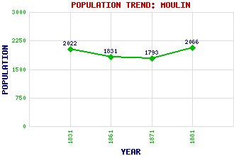
Moulin Classification and Statistics Settlement Type: hamlet Population (1881): 2066 (1871): 1793 (1861): 1831 (1831): 2022 Tourist Rating: N/A Text of Entry Updated: 02-AUG-2006 Location Latitude: 56.7125°N Longitude: 3.7267°W National Grid Reference: NN 944 592 A range of modern and historical maps are accessible through the map tab on the right of this page Get directions by entering the UK postcode of your location, home or hotel here eg. EH1 3YT Use the tabs on the right of this page to see other parts of this entry Related Entries There are 13 related entries. (3 Attractions, 1 Council Area, 1 Historical County, 3 Features, 1 Parish, 1 Person and 3 Settlements) Names that are not linked do not currently contain any information. Attractions: Moulin, Black Castle of Pitlochry & Moulin Heritage Centre Tummel Suspension Bridge Council Area: Perth and Kinross Features: Baledmund Balnakeilly Moulin Moor Historical Counties: Perthshire Parishes: Moulin People: Sir John Campbell of Moulin(1st Earl of Atholl) Settlements: Kinnaird Kirkmichael Pitlochry
There are 13 related entries. (3 Attractions, 1 Council Area, 1 Historical County, 3 Features, 1 Parish, 1 Person and 3 Settlements)
Names that are not linked do not currently contain any information.
By using our site you agree to accept cookies, which help us serve you better