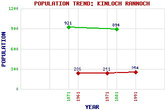
Kinloch Rannoch Classification and Statistics Settlement Type: village Population (1991): 254 (1971): 241 (1961): 236 (1881): 894 (1871): 921 Tourist Rating: Yes Text of Entry Updated: 17-JUN-2018 Location Latitude: 56.7008°N Longitude: 4.1851°W National Grid Reference: NN 663 587 A range of modern and historical maps are accessible through the map tab on the right of this page Get directions by entering the UK postcode of your location, home or hotel here eg. EH1 3YT Use the tabs on the right of this page to see other parts of this entry Related Entries There are 38 related entries. (0 Attractions, 1 Council Area, 1 Historical County, 1 Event, 23 Features, 1 Parish, 2 People and 9 Settlements) Names that are not linked do not currently contain any information. Council Area: Perth and Kinross Events: 1745 Jacobite Rebellion Features: An Sgorr Beinn a' Chuallaich Carn Fiaclach Craiganour Forest Craiganour Lodge Creag a' Mhadaidh Crossmount Dall House Dunalastair Reservoir Errochty, Loch Geal Charn Lassintullich Meall Druidhe Meall Luaidhe Meall a' Bharr Meall nan Eun Rannoch Railway Station Rannoch, Glen Rannoch, Loch Sassunn, Glen Shallainn, Allt Talla Bheith Tummel, River Historical Counties: Perthshire Parishes: Fortingall People: Dugald Buchanan(D'ughall Bochanan) Thomas Telford Settlements: Camghouran Carie Dall Drumchastle Innerhadden Killichonan Pitlochry Rannoch Station Tempar
There are 38 related entries. (0 Attractions, 1 Council Area, 1 Historical County, 1 Event, 23 Features, 1 Parish, 2 People and 9 Settlements)
Names that are not linked do not currently contain any information.
By using our site you agree to accept cookies, which help us serve you better