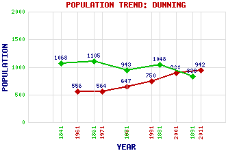
Dunning Classification and Statistics Settlement Type: village Population (2011): 942 (2001): 900 (1991): 750 (1981): 647 (1971): 564 (1961): 556 (1891): 838 (1881): 1048 (1871): 943 (1861): 1105 (1841): 1068 Tourist Rating: N/A Text of Entry Updated: 27-DEC-2012 Location Latitude: 56.3127°N Longitude: 3.5857°W National Grid Reference: NO 020 145 A range of modern and historical maps are accessible through the map tab on the right of this page Get directions by entering the UK postcode of your location, home or hotel here eg. EH1 3YT Use the tabs on the right of this page to see other parts of this entry Related Entries There are 34 related entries. (4 Attractions, 1 Council Area, 1 Historical County, 16 Features, 1 Parish, 2 People and 9 Settlements) Names that are not linked do not currently contain any information. Attractions: Fountain, The Maggie Wall's Monument Rollo Park St Serf's Church Council Area: Perth and Kinross Features: Balquhandy Hill Clevage Loch Cock Law Common of Dunning Craigbaikie Hill Duncrub Dunning Burn Dunning Golf Club Dupplin Castle Earn, Strath Glasgow-Perth Line Innerdouny Hill Muckle Law Ochil Hills Skymore Hill Stewartry of Strathearn Historical Counties: Perthshire Parishes: Dunning People: Ian Brady(Ian Duncan Stewart) Saint Serf(St. Serf) Settlements: Baldinnies Broom of Dalreoch Culross Dalreoch Forteviot Newton of Pitcairns Pathstruie Perth Pitcairn
There are 34 related entries. (4 Attractions, 1 Council Area, 1 Historical County, 16 Features, 1 Parish, 2 People and 9 Settlements)
Names that are not linked do not currently contain any information.
By using our site you agree to accept cookies, which help us serve you better