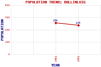
Ballinluig Classification and Statistics Settlement Type: village Population (1991): 235 (1961): 256 Tourist Rating: No Text of Entry Updated: 07-FEB-2020 Location Latitude: 56.6548°N Longitude: 3.6702°W National Grid Reference: NN 977 527 A range of modern and historical maps are accessible through the map tab on the right of this page Get directions by entering the UK postcode of your location, home or hotel here eg. EH1 3YT Use the tabs on the right of this page to see other parts of this entry Related Entries There are 18 related entries. (1 Attraction, 1 Council Area, 1 Historical County, 6 Features, 1 Parish, 0 People and 8 Settlements) Names that are not linked do not currently contain any information. Attractions: Tummel, Strath Council Area: Perth and Kinross Features: Highland Line Kinnaird House Oisinneach Mor, Lochan Ordie, Loch Skiach, Loch Tummel, River Historical Counties: Perthshire Parishes: Logierait Settlements: Aberfeldy Grandtully Kirkmichael Logierait Milton of Dalcapon Pitlochry Strathtay Tulliemet
There are 18 related entries. (1 Attraction, 1 Council Area, 1 Historical County, 6 Features, 1 Parish, 0 People and 8 Settlements)
Names that are not linked do not currently contain any information.
By using our site you agree to accept cookies, which help us serve you better