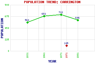
Carrington (Primrose) Classification and Statistics Settlement Type: hamlet Population (1971): 105 (1881): 606 (1871): 712 (1861): 681 (1831): 561 Tourist Rating: Yes Text of Entry Updated: 19-APR-2011 Location Latitude: 55.8328°N Longitude: 3.0904°W National Grid Reference: NT 317 605 A range of modern and historical maps are accessible through the map tab on the right of this page Get directions by entering the UK postcode of your location, home or hotel here eg. EH1 3YT References and Further Reading McWilliam, Colin (1978) The Buildings of Scotland: Lothian except Edinburgh. Penguin Books Ltd., Harmondsworth, Middlesex Use the tabs on the right of this page to see other parts of this entry Related Entries There are 11 related entries. (1 Attraction, 1 Council Area, 1 Historical County, 2 Families, 2 Features, 1 Parish, 1 Person and 2 Settlements) Names that are not linked do not currently contain any information. Attractions: Arniston House Council Area: Midlothian Families: Primrose Ramsay Features: Carrington Bridge Whitehill House Historical Counties: Midlothian Parishes: Carrington People: Archibald Hood Settlements: Gorebridge Rosewell
There are 11 related entries. (1 Attraction, 1 Council Area, 1 Historical County, 2 Families, 2 Features, 1 Parish, 1 Person and 2 Settlements)
Names that are not linked do not currently contain any information.
By using our site you agree to accept cookies, which help us serve you better