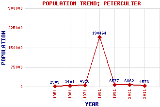
Peterculter (Culter) Classification and Statistics Settlement Type: village Population (2011): 4576 (2001): 6662(Combined with Milltimber) (1991): 6577(Combined with Milltimber) (1981): 190464(Combined with Aberdeen) (1971): 4918(Combined with Milltimber) (1961): 3401(Combined with Milltimber) (1951): 2309 Tourist Rating: Text of Entry Updated: 12-SEP-2016 Location Latitude: 57.096°N Longitude: 2.2689°W National Grid Reference: NJ 838 006 A range of modern and historical maps are accessible through the map tab on the right of this page Get directions by entering the UK postcode of your location, home or hotel here eg. EH1 3YT Use the tabs on the right of this page to see other parts of this entry Related Entries There are 31 related entries. (5 Attractions, 1 Council Area, 1 Historical County, 2 Families, 10 Features, 1 Parish, 1 Person and 10 Settlements) Names that are not linked do not currently contain any information. Attractions: Deeside Way Drum Castle Rob Roy Statue Royal Deeside Railway, The St Peter's Heritage Centre Council Area: Aberdeen City Families: Cumming Duff Features: Beans Hill Culter Burn Culter Helipad Culter House Dee, River Leuchar Burn Meikle Carewe Hill Milltimber, Hill of Normandykes Roman Camp Peterculter Golf Course Historical Counties: Aberdeenshire Parishes: Peterculter People: Robert (Rob Roy) MacGregor Settlements: Aberdeen Anguston Benthoul Bieldside Camphill Drumoak Hardgate Maryculter Milltimber Milton of Murtle
There are 31 related entries. (5 Attractions, 1 Council Area, 1 Historical County, 2 Families, 10 Features, 1 Parish, 1 Person and 10 Settlements)
Names that are not linked do not currently contain any information.
By using our site you agree to accept cookies, which help us serve you better