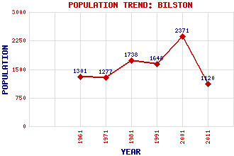
Bilston Classification and Statistics Settlement Type: village Population (2011): 1120 (2001): 2371 (1991): 1648 (1981): 1738 (1971): 1277 (1961): 1301 Tourist Rating: No Text of Entry Updated: 09-MAY-2021 Location Latitude: 55.8707°N Longitude: 3.1793°W National Grid Reference: NT 263 648 A range of modern and historical maps are accessible through the map tab on the right of this page Get directions by entering the UK postcode of your location, home or hotel here eg. EH1 3YT Use the tabs on the right of this page to see other parts of this entry Related Entries There are 12 related entries. (1 Attraction, 1 Council Area, 1 Historical County, 5 Features, 1 Parish, 0 People and 3 Settlements) Names that are not linked do not currently contain any information. Attractions: Bilston Glen Viaduct Council Area: Midlothian Features: Bilston Burn Bilston Glen Bilston Industrial Estate Dryden Tower Royal (Dick) School of Veterinary Studies Historical Counties: Midlothian Parishes: Lasswade Settlements: Langhill Farm Loanhead Seafield
There are 12 related entries. (1 Attraction, 1 Council Area, 1 Historical County, 5 Features, 1 Parish, 0 People and 3 Settlements)
Names that are not linked do not currently contain any information.
By using our site you agree to accept cookies, which help us serve you better