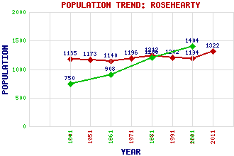
Rosehearty Classification and Statistics Settlement Type: village Population (2011): 1322 (2001): 1194 (1991): 1202 (1981): 1242 (1971): 1196 (1961): 1140 (1951): 1173 (1901): 1185(Police Burgh) (1881): 1404 (1871): 1206 (1861): 908 (1841): 750 Tourist Rating: Text of Entry Updated: 08-NOV-2003 Location Latitude: 57.6972°N Longitude: 2.1157°W National Grid Reference: NJ 932 675 A range of modern and historical maps are accessible through the map tab on the right of this page Get directions by entering the UK postcode of your location, home or hotel here eg. EH1 3YT Use the tabs on the right of this page to see other parts of this entry Related Entries There are 24 related entries. (2 Attractions, 1 Council Area, 1 Historical County, 3 Families, 8 Features, 1 Parish, 2 People and 6 Settlements) Names that are not linked do not currently contain any information. Attractions: Mounthooly Doo'cot Pittulie Castle Council Area: Aberdeenshire Families: Cumming Forbes Fraser Features: Moray Firth Pennan Bay Pennan Head Phingask Shore Pitsligo Castle Pitsligo Parish Church Quarry Head Rosehearty Golf Club Historical Counties: Aberdeenshire Parishes: Pitsligo People: Robert Gordon McBeath Lorna Moon(Helen Low) Settlements: Fraserburgh New Aberdour Peathill Pennan Pittulie Sandhaven
There are 24 related entries. (2 Attractions, 1 Council Area, 1 Historical County, 3 Families, 8 Features, 1 Parish, 2 People and 6 Settlements)
Names that are not linked do not currently contain any information.
By using our site you agree to accept cookies, which help us serve you better