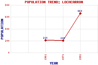
Lochcarron Classification and Statistics Settlement Type: village Population (1991): 660 (1971): 204 (1961): 210 Tourist Rating: No Text of Entry Updated: 08-AUG-2008 Location Latitude: 57.397°N Longitude: 5.5033°W National Grid Reference: NG 896 395 A range of modern and historical maps are accessible through the map tab on the right of this page Get directions by entering the UK postcode of your location, home or hotel here eg. EH1 3YT Use the tabs on the right of this page to see other parts of this entry Related Entries There are 15 related entries. (0 Attractions, 1 Council Area, 1 Historical County, 7 Features, 1 Parish, 0 People and 5 Settlements) Names that are not linked do not currently contain any information. Council Area: Highland Features: An Sgurr Carron, Loch Glas Bheinn Lochcarron Golf Club Sgurr a' Gharaidh Strathcarron Railway Station Wester Ross Historical Counties: Ross and Cromarty Parishes: Lochcarron Settlements: Achintee Achnashellach Ardarroch New Kelso Slumbay
There are 15 related entries. (0 Attractions, 1 Council Area, 1 Historical County, 7 Features, 1 Parish, 0 People and 5 Settlements)
Names that are not linked do not currently contain any information.
By using our site you agree to accept cookies, which help us serve you better