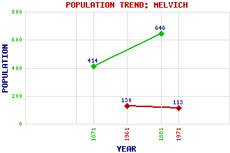
Melvich Classification and Statistics Settlement Type: village Population (1971): 113 (1961): 130 (1881): 646 (1871): 414 Tourist Rating: N/A Text of Entry Updated: 16-JUL-2007 Location Latitude: 58.5523°N Longitude: 3.9229°W National Grid Reference: NC 882 643 A range of modern and historical maps are accessible through the map tab on the right of this page Get directions by entering the UK postcode of your location, home or hotel here eg. EH1 3YT Use the tabs on the right of this page to see other parts of this entry Related Entries There are 19 related entries. (0 Attractions, 1 Council Area, 1 Historical County, 6 Features, 1 Parish, 0 People and 10 Settlements) Names that are not linked do not currently contain any information. Council Area: Highland Features: Baligill Head Bighouse Bighouse Hill Forsinard Railway Station Melvich Bay Sutherland Historical Counties: Sutherland Parishes: Farr Settlements: Achiemore Baligill Croick Dalhalvaig Portskerra Strathy Thurso Trantlebeg Trantlemore Upper Bighouse
There are 19 related entries. (0 Attractions, 1 Council Area, 1 Historical County, 6 Features, 1 Parish, 0 People and 10 Settlements)
Names that are not linked do not currently contain any information.
By using our site you agree to accept cookies, which help us serve you better