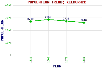
Kilmorack Classification and Statistics Settlement Type: hamlet Population (1881): 2618 (1871): 2728 (1861): 2852 (1831): 2709 Tourist Rating: Yes Text of Entry Updated: 03-JAN-2010 Location Latitude: 57.4638°N Longitude: 4.514°W National Grid Reference: NH 493 443 A range of modern and historical maps are accessible through the map tab on the right of this page Get directions by entering the UK postcode of your location, home or hotel here eg. EH1 3YT Use the tabs on the right of this page to see other parts of this entry Related Entries There are 14 related entries. (0 Attractions, 1 Council Area, 1 Historical County, 9 Features, 1 Parish, 0 People and 2 Settlements) Names that are not linked do not currently contain any information. Council Area: Highland Features: Affric-Beauly Hydro-Electric Power Scheme Aigas Power Station An Druim Beauly, River Easter Ross Kilmorack Power Station Kilmorack, Falls of Sliabhach Strathfarrar, Glen Historical Counties: Inverness-shire Parishes: Kilmorack Settlements: Fanellan Inverness
There are 14 related entries. (0 Attractions, 1 Council Area, 1 Historical County, 9 Features, 1 Parish, 0 People and 2 Settlements)
Names that are not linked do not currently contain any information.
By using our site you agree to accept cookies, which help us serve you better