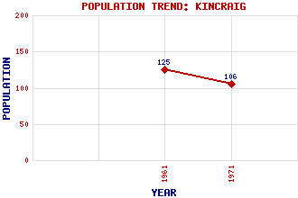
Kincraig (Boat of Insh) Classification and Statistics Settlement Type: village Population (1971): 106 (1961): 125 Tourist Rating: N/A Text of Entry Updated: 15-JUL-2019 Location Latitude: 57.1273°N Longitude: 3.931°W National Grid Reference: NH 832 057 A range of modern and historical maps are accessible through the map tab on the right of this page Get directions by entering the UK postcode of your location, home or hotel here eg. EH1 3YT Use the tabs on the right of this page to see other parts of this entry Related Entries There are 40 related entries. (7 Attractions, 1 Council Area, 1 Historical County, 1 Event, 21 Features, 1 Parish, 2 People and 6 Settlements) Names that are not linked do not currently contain any information. Attractions: Badenoch Way Frank Bruce Sculpture Trail Highland Wildlife Park Insh Marshes Loch Insh Outdoor Centre Speyside Way St Drostan's Chapel Council Area: Highland Events: Cairngorm Disaster Features: A9 Trunk Road An Suidhe Badenoch Badenoch and Strathspey Beag, Loch Cannich, Glen Carn Ban Mor Dalraddy Holiday Park Dunachton Symbol Stone Feshie, Glen Feshie, River Geal-charn Glenfeshie Lodge Highland Line Insh Church Insh, Loch Kincraig Bridge Kincraig House Lagganlia Centre for Outdoor Education Spey, River Tom Dubh Historical Counties: Inverness-shire Parishes: Alvie People: Saint Adamnan(St. Adamnan) Anders Holch Povlsen Settlements: Alvie Aviemore Baldow Kingussie Leault Farm Milehead
There are 40 related entries. (7 Attractions, 1 Council Area, 1 Historical County, 1 Event, 21 Features, 1 Parish, 2 People and 6 Settlements)
Names that are not linked do not currently contain any information.
By using our site you agree to accept cookies, which help us serve you better