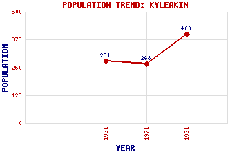
Kyleakin Classification and Statistics Settlement Type: village Population (1991): 400 (1971): 268 (1961): 281 Tourist Rating: Yes Text of Entry Updated: 21-MAR-2003 Location Latitude: 57.2719°N Longitude: 5.7287°W National Grid Reference: NG 753 263 A range of modern and historical maps are accessible through the map tab on the right of this page Get directions by entering the UK postcode of your location, home or hotel here eg. EH1 3YT References and Further Reading Gifford, John (1992) The Buildings of Scotland: Highland and Islands. Penguin, London Use the tabs on the right of this page to see other parts of this entry Related Entries There are 23 related entries. (4 Attractions, 1 Council Area, 1 Historical County, 1 Family, 8 Features, 1 Parish, 3 People and 4 Settlements) Names that are not linked do not currently contain any information. Attractions: Bright Water Visitor Centre Castle Moil Skye Skye Bridge Council Area: Highland Families: MacKinnon Features: Ban, Eilean Beinn Dubh a' Bhealaich Beinn na Caillich Ben Aslak Kyle Akin Kyle Rhea Mor, Eilean Skye and Lochalsh Historical Counties: Inverness-shire Parishes: Strath People: James Gillespie Graham David Stevenson Thomas Stevenson Settlements: Breakish Broadford Kyle of Lochalsh Lusa
There are 23 related entries. (4 Attractions, 1 Council Area, 1 Historical County, 1 Family, 8 Features, 1 Parish, 3 People and 4 Settlements)
Names that are not linked do not currently contain any information.
By using our site you agree to accept cookies, which help us serve you better