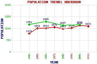
Aberdour Classification and Statistics Settlement Type: village Population (2011): 1633 (2001): 1690 (1991): 1524 (1981): 1470 (1971): 1576 (1961): 1510 (1951): 1502 (1901): 1176(Police Burgh) (1881): 1736 (1871): 1697 (1851): 1945 (1831): 1751 Tourist Rating: Text of Entry Updated: 07-AUG-2022 Location Latitude: 56.0546°N Longitude: 3.2941°W National Grid Reference: NT 195 854 A range of modern and historical maps are accessible through the map tab on the right of this page Get directions by entering the UK postcode of your location, home or hotel here eg. EH1 3YT Use the tabs on the right of this page to see other parts of this entry Related Entries There are 33 related entries. (4 Attractions, 1 Council Area, 1 Historical County, 18 Features, 1 Parish, 4 People and 4 Settlements) Names that are not linked do not currently contain any information. Attractions: Aberdour Castle Fife Coastal Path Inchcolm Inchcolm Abbey Council Area: Fife Features: Aberdour Golf Club Aberdour Railway Station Braefoot Bay Marine Terminal Braefoot Point Car Craig Couston Castle Craigdimas Cullaloe Hills Dalgety Bay East Coast Main Line Easterheughs Castle Forth, Firth of Hawkcraig Point Mortimer's Deep Silversands Bay St Fillan's Church Stenhouse Reservoir Torry Hill Historical Counties: Fife Parishes: Aberdour People: Rev. Robert Blair Sir William Douglas(Knight of Liddesdale) Saint Fillan(St. Fillan) William Lambie Moffatt(William Moffat) Settlements: Burntisland Cullaloe Dalgety Bay Inverkeithing
There are 33 related entries. (4 Attractions, 1 Council Area, 1 Historical County, 18 Features, 1 Parish, 4 People and 4 Settlements)
Names that are not linked do not currently contain any information.
By using our site you agree to accept cookies, which help us serve you better