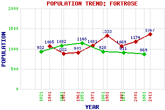
Fortrose Classification and Statistics Settlement Type: village Population (2011): 1367 (2001): 1174 (1991): 1069 (1981): 1333 (1971): 1081 (1961): 903 (1951): 882 (1901): 1065(Parliamentary and Municipal Burgh) (1881): 869 (1871): 911 (1861): 928 (1851): 1148 (1841): 1082 (1821): 932 Tourist Rating: Yes Text of Entry Updated: 04-MAY-2011 Location Latitude: 57.5796°N Longitude: 4.1322°W National Grid Reference: NH 726 564 A range of modern and historical maps are accessible through the map tab on the right of this page Get directions by entering the UK postcode of your location, home or hotel here eg. EH1 3YT Use the tabs on the right of this page to see other parts of this entry Related Entries There are 19 related entries. (2 Attractions, 1 Council Area, 1 Historical County, 1 Family, 8 Features, 1 Parish, 3 People and 2 Settlements) Names that are not linked do not currently contain any information. Attractions: Fort George Fortrose Cathedral Council Area: Highland Families: Ross Features: Black Isle Chanonry Point Cromarty Firth Fortrose Academy Fortrose and Rosemarkie Golf Course Inverness Firth Muir of Ord Railway Station Tore Roundabout Historical Counties: Ross and Cromarty Parishes: Rosemarkie People: King David I Alexander Nimmo John Rhind Settlements: Avoch Rosemarkie
There are 19 related entries. (2 Attractions, 1 Council Area, 1 Historical County, 1 Family, 8 Features, 1 Parish, 3 People and 2 Settlements)
Names that are not linked do not currently contain any information.
By using our site you agree to accept cookies, which help us serve you better