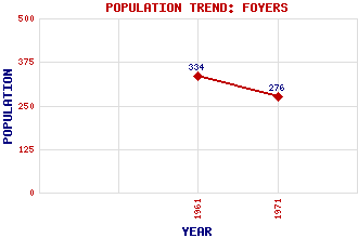
Foyers Classification and Statistics Settlement Type: settlement Population (1971): 276 (1961): 334 Tourist Rating: N/A Text of Entry Updated: 07-JUL-2009 Location Latitude: 57.2539°N Longitude: 4.4947°W National Grid Reference: NH 496 209 A range of modern and historical maps are accessible through the map tab on the right of this page Get directions by entering the UK postcode of your location, home or hotel here eg. EH1 3YT Use the tabs on the right of this page to see other parts of this entry Related Entries There are 19 related entries. (2 Attractions, 1 Council Area, 1 Historical County, 8 Features, 1 Parish, 0 People and 6 Settlements) Names that are not linked do not currently contain any information. Attractions: Foyers, Falls of Ness, Loch Council Area: Highland Features: Bonagour's Cave Brein, Glen Carn Dearg Dearg Lochain Foyers, River Mhor, Loch Scristan, Lochan t-Sluichd, Allt an Historical Counties: Inverness-shire Parishes: Boleskine and Abertarff Settlements: Aultnagoire Boleskine Fort Augustus Inverfarigaig Lochgarthside Wester Aberchalder
There are 19 related entries. (2 Attractions, 1 Council Area, 1 Historical County, 8 Features, 1 Parish, 0 People and 6 Settlements)
Names that are not linked do not currently contain any information.
By using our site you agree to accept cookies, which help us serve you better