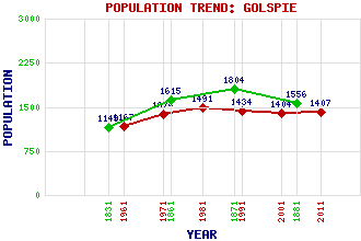
Golspie Classification and Statistics Settlement Type: village Population (2011): 1407 (2001): 1404 (1991): 1434 (1981): 1491 (1971): 1374 (1961): 1167 (1881): 1556 (1871): 1804 (1861): 1615 (1831): 1149 Tourist Rating: N/A Text of Entry Updated: 03-MAR-2020 Location Latitude: 57.9747°N Longitude: 3.9781°W National Grid Reference: NC 831 001 A range of modern and historical maps are accessible through the map tab on the right of this page Get directions by entering the UK postcode of your location, home or hotel here eg. EH1 3YT Use the tabs on the right of this page to see other parts of this entry Related Entries There are 35 related entries. (4 Attractions, 1 Council Area, 1 Historical County, 16 Features, 1 Parish, 4 People and 8 Settlements) Names that are not linked do not currently contain any information. Attractions: Carn Liath Dunrobin Castle Fleet, Loch North Coast 500 Council Area: Highland Features: A9 Trunk Road Aberscross Hill Balblair Wood Beinn Bhragaidh Ben Horn Ben Lundie Brora Railway Station Creag an Amalaidh Dunrobin Castle Railway Station Golspie Golf Club Golspie High School Golspie Railway Station Horn, Loch Lundie, Loch Mound Rock Sutherland Historical Counties: Sutherland Parishes: Golspie People: John Lennon Elizabeth Leveson-Gower(Countess of Sutherland) George Granville Leveson-Gower(1st Duke of Sutherland) Prof. Ian McIntyre Settlements: Backies Dornoch Drummuie Kinlochbervie Littleferry Morvich Rogart West Langwell
There are 35 related entries. (4 Attractions, 1 Council Area, 1 Historical County, 16 Features, 1 Parish, 4 People and 8 Settlements)
Names that are not linked do not currently contain any information.
By using our site you agree to accept cookies, which help us serve you better