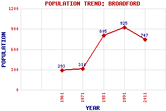
Broadford Classification and Statistics Settlement Type: village Population (2011): 747 (1991): 925 (1981): 805(Combined with Breakish and Waterloo) (1971): 310 (1961): 293 Tourist Rating: N/A Text of Entry Updated: 06-JUN-2006 Location Latitude: 57.2405°N Longitude: 5.9046°W National Grid Reference: NG 645 234 A range of modern and historical maps are accessible through the map tab on the right of this page Get directions by entering the UK postcode of your location, home or hotel here eg. EH1 3YT Use the tabs on the right of this page to see other parts of this entry Related Entries There are 43 related entries. (3 Attractions, 1 Council Area, 1 Historical County, 21 Features, 1 Parish, 0 People and 16 Settlements) Names that are not linked do not currently contain any information. Attractions: Cuillin Hills National Scenic Area Skye Skye Serpentarium Council Area: Highland Features: Ainort, Loch Arroch, Glen Beinn Dearg Mhor Beinn na Caillich Beinn na Seamraig Ben Suardal Blaven Broadford Bay Carn Dearg Cill Chriosd Cill Chriosd, Loch Clach Glas Glas Bheinn Mhor Isle of Skye Airport Lonachan, Loch Mullach na Carn Pabay Red Cuillin Skye and Lochalsh Suardal, Glen Suardal, Strath Historical Counties: Inverness-shire Parishes: Strath Settlements: Boreraig Breakish Camasunary Corry Drumfearn Duisdalemore Elgol Harrapool Isleornsay Kilchrist Kyleakin Lower Breakish Portree Skulamus Torrin Waterloo
There are 43 related entries. (3 Attractions, 1 Council Area, 1 Historical County, 21 Features, 1 Parish, 0 People and 16 Settlements)
Names that are not linked do not currently contain any information.
By using our site you agree to accept cookies, which help us serve you better