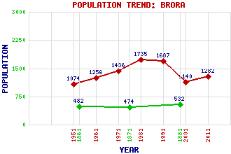
Brora (Inverbrora) Classification and Statistics Settlement Type: village Population (2011): 1282 (2001): 1140 (1991): 1687 (1981): 1735 (1971): 1436 (1961): 1256 (1951): 1074 (1881): 532 (1871): 474 (1861): 482 Tourist Rating: N/A Text of Entry Updated: 06-JUN-2006 Location Latitude: 58.0116°N Longitude: 3.8531°W National Grid Reference: NC 906 040 A range of modern and historical maps are accessible through the map tab on the right of this page Get directions by entering the UK postcode of your location, home or hotel here eg. EH1 3YT Use the tabs on the right of this page to see other parts of this entry Related Entries There are 28 related entries. (3 Attractions, 1 Council Area, 1 Historical County, 12 Features, 1 Parish, 0 People and 10 Settlements) Names that are not linked do not currently contain any information. Attractions: Carn Liath Clynelish Distillery North Coast 500 Council Area: Highland Features: A9 Trunk Road Beinn Smeoral Brora Golf Course Brora Railway Station Brora, Loch Brora, River Col-bheinn Dudgeon Park Gordonbush Wind Farm Skinsdale, River Sletdale, Glen Sutherland Historical Counties: Sutherland Parishes: Clyne Settlements: Achrimsdale Badbea Berriedale Clyne Clynelish Dalchalm Doll East Clyne Helmsdale West Clyne
There are 28 related entries. (3 Attractions, 1 Council Area, 1 Historical County, 12 Features, 1 Parish, 0 People and 10 Settlements)
Names that are not linked do not currently contain any information.
By using our site you agree to accept cookies, which help us serve you better