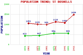
St Boswells (Lessuden) Classification and Statistics Settlement Type: village Population (2011): 1494 (2001): 1086 (1991): 1128 (1981): 999 (1971): 1009 (1961): 1052 (1881): 555 (1871): 556 (1861): 447 (1831): 433 Tourist Rating: Text of Entry Updated: 27-JUL-2019 Location Latitude: 55.57°N Longitude: 2.6469°W National Grid Reference: NT 593 309 A range of modern and historical maps are accessible through the map tab on the right of this page Get directions by entering the UK postcode of your location, home or hotel here eg. EH1 3YT Use the tabs on the right of this page to see other parts of this entry Related Entries There are 34 related entries. (3 Attractions, 1 Council Area, 1 Historical County, 4 Families, 7 Features, 1 Parish, 4 People and 13 Settlements) Names that are not linked do not currently contain any information. Attractions: Ancrum Moor Borders Railway Dryburgh Abbey Council Area: Scottish Borders Families: Buccleuch Haig Kerr Scott Features: Mertoun Bridge Roxburghshire St Boswells Golf Club St Boswells Station St Cuthbert's Way Tweed Horizons Tweed, River Historical Counties: Roxburghshire Parishes: St Boswells People: Lady Grisell Baillie Saint Boswell(St. Boswell, St. Boisil, St. Bosiel) Field Marshal Douglas Haig(Earl Haig of Bemersyde) Sir Walter Scott Settlements: Benrig Bowden Camieston Charlesfield Clintmains Dryburgh Earlston Greycrook Longnewton Maxton Melrose Newstead Newtown St Boswells
There are 34 related entries. (3 Attractions, 1 Council Area, 1 Historical County, 4 Families, 7 Features, 1 Parish, 4 People and 13 Settlements)
Names that are not linked do not currently contain any information.
By using our site you agree to accept cookies, which help us serve you better