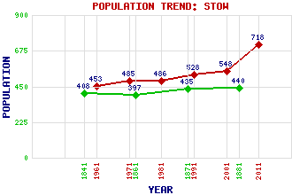
Stow Classification and Statistics Settlement Type: village Population (2011): 718 (2001): 548 (1991): 528 (1981): 486 (1971): 485 (1961): 453 (1881): 440 (1871): 435 (1861): 397 (1841): 408 Tourist Rating: Text of Entry Updated: 10-SEP-2015 Location Latitude: 55.6918°N Longitude: 2.8621°W National Grid Reference: NT 459 446 A range of modern and historical maps are accessible through the map tab on the right of this page Get directions by entering the UK postcode of your location, home or hotel here eg. EH1 3YT Use the tabs on the right of this page to see other parts of this entry Related Entries There are 30 related entries. (1 Attraction, 1 Council Area, 1 Historical County, 8 Features, 1 Parish, 5 People and 13 Settlements) Names that are not linked do not currently contain any information. Attractions: Borders Railway Council Area: Scottish Borders Features: A7 Trunk Road Burnhouse Ferniehirst Hill Gala Water Lugate Water Moorfoot Hills Stow Railway Station Torquhan Historical Counties: Midlothian Parishes: Stow People: King Arthur Bishop Clement W.I. Douglas Elliot William Ewart Gladstone Gilbert Innes of Stow Settlements: Abbey St Bathans Bowland Cathpair Fountainhall Galashiels Heriot Killochyett Langshaw Lauder St Andrews Threepwood Torsonce Wooplaw
There are 30 related entries. (1 Attraction, 1 Council Area, 1 Historical County, 8 Features, 1 Parish, 5 People and 13 Settlements)
Names that are not linked do not currently contain any information.
By using our site you agree to accept cookies, which help us serve you better