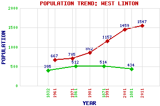
West Linton Classification and Statistics Settlement Type: village Population (2011): 1547 (2001): 1459 (1991): 1157 (1981): 852 (1971): 705 (1961): 667 (1881): 434 (1871): 514 (1861): 512 (1832): 395 Tourist Rating: Text of Entry Updated: 22-AUG-2019 Location Latitude: 55.7529°N Longitude: 3.3574°W National Grid Reference: NT 149 519 A range of modern and historical maps are accessible through the map tab on the right of this page Get directions by entering the UK postcode of your location, home or hotel here eg. EH1 3YT Use the tabs on the right of this page to see other parts of this entry Related Entries There are 34 related entries. (1 Attraction, 1 Council Area, 1 Historical County, 16 Features, 1 Parish, 4 People and 10 Settlements) Names that are not linked do not currently contain any information. Attractions: Cross Borders Drove Road Council Area: Scottish Borders Features: Baddinsgill Burn Baddinsgill Reservoir Bell Tower, The Bleak Law Cairn Burn Darlees Rig Harrows Law King Seat Lyne Water Mendick Hill North Esk Reservoir Pentland Hills West Linton Golf Club West Water West Water Reservoir White Craig Historical Counties: Peeblesshire Parishes: West Linton People: Victoria Crowe Alexander (Sandy) Lyle William Mossman Ronald Stevenson Settlements: Baddinsgill Blyth Bridge Carlops Cowieslinn Dolphinton Edinburgh Lamancha Mountain Cross Penicuik Romanno Bridge
There are 34 related entries. (1 Attraction, 1 Council Area, 1 Historical County, 16 Features, 1 Parish, 4 People and 10 Settlements)
Names that are not linked do not currently contain any information.
By using our site you agree to accept cookies, which help us serve you better