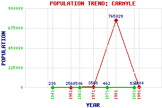
Carmyle Classification and Statistics Settlement Type: suburb Population (1991): 7000 (1981): 765029(Combined with Glasgow) (1971): 3568 (1951): 2568 (1881): 536 (1871): 462 (1861): 506 (1841): 238 Tourist Rating: No Text of Entry Updated: 02-APR-2017 Location Latitude: 55.834°N Longitude: 4.1586°W National Grid Reference: NS 649 622 A range of modern and historical maps are accessible through the map tab on the right of this page Get directions by entering the UK postcode of your location, home or hotel here eg. EH1 3YT Use the tabs on the right of this page to see other parts of this entry Related Entries There are 21 related entries. (0 Attractions, 1 Council Area, 1 Historical County, 12 Features, 1 Parish, 4 People and 2 Settlements) Names that are not linked do not currently contain any information. Council Area: Glasgow City Features: Bogleshole Bridge Cambuslang Bridge Cambuslang Footbridge Carmyle Railway Station City Union Railway Bridge Clyde, River Clydebridge Steelworks Clydebridge Viaduct Clydeford Bridge Fullarton M74 Motorway Whifflet Line Historical Counties: Lanarkshire Parishes: Old Monkland People: William Cadell Thomas Edington James Beaumont Neilson Walter Smith Settlements: Glasgow Mount Vernon
There are 21 related entries. (0 Attractions, 1 Council Area, 1 Historical County, 12 Features, 1 Parish, 4 People and 2 Settlements)
Names that are not linked do not currently contain any information.
By using our site you agree to accept cookies, which help us serve you better