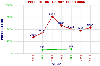
Blackburn Classification and Statistics Settlement Type: small town Population (2011): 5338 (2001): 4761 (1991): 5014 (1981): 5786 (1971): 7636 (1961): 4302 (1951): 3354 (1871): 954 (1861): 758 Tourist Rating: No Text of Entry Updated: 04-MAR-2020 Location Latitude: 55.8764°N Longitude: 3.6254°W National Grid Reference: NS 984 660 A range of modern and historical maps are accessible through the map tab on the right of this page Get directions by entering the UK postcode of your location, home or hotel here eg. EH1 3YT Use the tabs on the right of this page to see other parts of this entry Related Entries There are 22 related entries. (1 Attraction, 1 Council Area, 1 Historical County, 5 Features, 1 Parish, 2 People and 11 Settlements) Names that are not linked do not currently contain any information. Attractions: Easter Inch Moss Council Area: West Lothian Features: Almond Valley Almond, River King George V Park Pinewood School St Kentigern's Academy Historical Counties: West Lothian Parishes: Livingston People: Susan Boyle Lewis Capaldi Settlements: Addiewell Bathgate East Calder East Whitburn Edinburgh Glasgow Livingston Loganlea Seafield Wester Breich Whitburn
There are 22 related entries. (1 Attraction, 1 Council Area, 1 Historical County, 5 Features, 1 Parish, 2 People and 11 Settlements)
Names that are not linked do not currently contain any information.
By using our site you agree to accept cookies, which help us serve you better