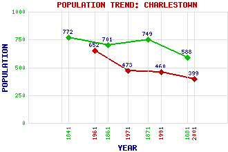
Charlestown Classification and Statistics Settlement Type: village Population (2001): 399 (1991): 460 (1971): 473 (1961): 652 (1881): 588 (1871): 749 (1861): 701 (1841): 772 Tourist Rating: Text of Entry Updated: 31-DEC-2011 Location Latitude: 56.0361°N Longitude: 3.5021°W National Grid Reference: NT 065 836 A range of modern and historical maps are accessible through the map tab on the right of this page Get directions by entering the UK postcode of your location, home or hotel here eg. EH1 3YT References and Further Reading Fotheringham, Norman (1997) Charlestown: Built on lime. Carnegie Dunfermline Trust, Dunfermline Use the tabs on the right of this page to see other parts of this entry Related Entries There are 12 related entries. (1 Attraction, 1 Council Area, 1 Historical County, 1 Family, 2 Features, 1 Parish, 4 People and 1 Settlement) Names that are not linked do not currently contain any information. Attractions: Scottish Lime Centre, The Council Area: Fife Families: Bruce Features: Broomhall Ironmill Bay Historical Counties: Fife Parishes: Dunfermline People: Sir Robert Rowand Anderson Charles Bruce(5th Earl of Elgin) Queen Victoria Sir William Whyte Settlements: Dunfermline
There are 12 related entries. (1 Attraction, 1 Council Area, 1 Historical County, 1 Family, 2 Features, 1 Parish, 4 People and 1 Settlement)
Names that are not linked do not currently contain any information.
By using our site you agree to accept cookies, which help us serve you better