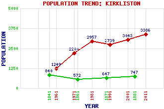
Kirkliston Classification and Statistics Settlement Type: settlement Population (2011): 3386 (2001): 3043 (1991): 2739 (1981): 2957 (1971): 2200 (1961): 1249 (1881): 747 (1871): 647 (1861): 572 (1841): 840 Tourist Rating: N/A Text of Entry Updated: 20-AUG-2009 Location Latitude: 55.9546°N Longitude: 3.4029°W National Grid Reference: NT 125 744 A range of modern and historical maps are accessible through the map tab on the right of this page Get directions by entering the UK postcode of your location, home or hotel here eg. EH1 3YT Use the tabs on the right of this page to see other parts of this entry Related Entries There are 20 related entries. (1 Attraction, 1 Council Area, 1 Historical County, 7 Features, 1 Parish, 4 People and 5 Settlements) Names that are not linked do not currently contain any information. Attractions: Pepper Wood Nature Reserve Council Area: City of Edinburgh Features: A9 Trunk Road Almond Valley Almond, River Carlowrie Castle Cat Stane Dolphington Burn Newliston Historical Counties: West Lothian Parishes: Kirkliston People: Isobel Wylie Hutchison Sir Robert Liston Sir John Murray Neil Speirs Settlements: Broxburn Carlowrie Edinburgh Ratho South Queensferry
There are 20 related entries. (1 Attraction, 1 Council Area, 1 Historical County, 7 Features, 1 Parish, 4 People and 5 Settlements)
Names that are not linked do not currently contain any information.
By using our site you agree to accept cookies, which help us serve you better