Garvald

Classification and Statistics
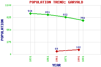
Settlement Type: village
Population (1991): 102    
(1961): 69
(1881): 758
(1871): 832
(1861): 891
(1831): 914

Tourist Rating: Yes
Text of Entry Updated: 07-APR-2009
Location

Latitude: 55.9285°N Longitude: 2.6609°W
National Grid Reference: NT 588 708
A range of modern and historical maps are accessible through the map tab on the right of this page
Get directions by entering the UK postcode of your location, home or hotel here eg. EH1 3YT
 

References and Further Reading
Hajducki, Andrew M. (1994) The Haddington, Macmerry and Gifford Branch Lines. The Oakwood Press, Oxford
McWilliam, Colin (1978) The Buildings of Scotland: Lothian except Edinburgh. Penguin Books Ltd., Harmondsworth, Middlesex
Whyte, Ian and Kathleen Whyte (1988) Discovering East Lothian. John Donald Publishers Ltd., Edinburgh

Use the tabs on the right of this page to see other parts of this entry arrow

Related Entries

There are 37 related entries.

(0 Attractions, 1 Council Area, 1 Historical County, 26 Features, 1 Parish, 2 People and 6 Settlements)

Names that are not linked do not currently contain any information.


If you have found this information useful please consider making
a donation to help maintain and improve this resource. More info...

By using our site you agree to accept cookies, which help us serve you better