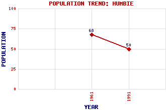
Humbie Classification and Statistics Settlement Type: hamlet Population (1991): 50 (1961): 68 Tourist Rating: N/A Text of Entry Updated: 24-SEP-2006 Location Latitude: 55.8544°N Longitude: 2.8689°W National Grid Reference: NT 457 627 A range of modern and historical maps are accessible through the map tab on the right of this page Get directions by entering the UK postcode of your location, home or hotel here eg. EH1 3YT References and Further Reading McWilliam, Colin (1978) The Buildings of Scotland: Lothian except Edinburgh. Penguin Books Ltd., Harmondsworth, Middlesex Use the tabs on the right of this page to see other parts of this entry Related Entries There are 20 related entries. (0 Attractions, 1 Council Area, 1 Historical County, 1 Family, 7 Features, 1 Parish, 3 People and 6 Settlements) Names that are not linked do not currently contain any information. Council Area: East Lothian Families: Fraser Features: Blegbie Hill Humbie Water Johnstounburn House Keith Marischal Lammermuir Hills Widow's Knowe Windy Law Historical Counties: East Lothian Parishes: Humbie People: David Bryce William Nicol George Waterston Settlements: Blegbie Fala Keith Pencaitland Shillinghill Upper Keith
There are 20 related entries. (0 Attractions, 1 Council Area, 1 Historical County, 1 Family, 7 Features, 1 Parish, 3 People and 6 Settlements)
Names that are not linked do not currently contain any information.
By using our site you agree to accept cookies, which help us serve you better