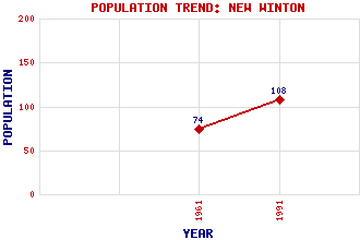
New Winton Classification and Statistics Settlement Type: village Population (1991): 108 (1961): 74 Tourist Rating: No Text of Entry Updated: 24-FEB-2002 Location Latitude: 55.9295°N Longitude: 2.9202°W National Grid Reference: NT 426 711 A range of modern and historical maps are accessible through the map tab on the right of this page Get directions by entering the UK postcode of your location, home or hotel here eg. EH1 3YT References and Further Reading Hajducki, Andrew M. (1994) The Haddington, Macmerry and Gifford Branch Lines. The Oakwood Press, Oxford Use the tabs on the right of this page to see other parts of this entry Related Entries There are 6 related entries. (0 Attractions, 1 Council Area, 1 Historical County, 0 Features, 1 Parish, 0 People and 3 Settlements) Names that are not linked do not currently contain any information. Council Area: East Lothian Historical Counties: East Lothian Parishes: Pencaitland Settlements: Macmerry Pencaitland Tranent
There are 6 related entries. (0 Attractions, 1 Council Area, 1 Historical County, 0 Features, 1 Parish, 0 People and 3 Settlements)
Names that are not linked do not currently contain any information.
By using our site you agree to accept cookies, which help us serve you better