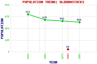
Oldhamstocks Classification and Statistics Settlement Type: hamlet Population (1991): 50 (1881): 568 (1871): 592 (1861): 615 (1831): 720 Tourist Rating: Yes Text of Entry Updated: 18-JUL-2019 Location Latitude: 55.9277°N Longitude: 2.416°W National Grid Reference: NT 741 706 A range of modern and historical maps are accessible through the map tab on the right of this page Get directions by entering the UK postcode of your location, home or hotel here eg. EH1 3YT Use the tabs on the right of this page to see other parts of this entry Related Entries There are 25 related entries. (1 Attraction, 1 Council Area, 1 Historical County, 1 Family, 16 Features, 1 Parish, 2 People and 2 Settlements) Names that are not linked do not currently contain any information. Attractions: St Mary's Collegiate Church Council Area: East Lothian Families: Hepburn Features: Aikengall Community Wind Farm Birny Knowe Broom Hill Burn Hope Cocklaw Hill Corse Law East Lammermuir Deans Nature Reserve Ecclaw Hill Eye Water Heriot Water Needle Hill North Sea Paits Hill Saddle Hill Weather Law Wightman Hill Historical Counties: East Lothian Parishes: Oldhamstocks People: John Broadwood Dr. John Kitchen Settlements: Cockburnspath Dunbar
There are 25 related entries. (1 Attraction, 1 Council Area, 1 Historical County, 1 Family, 16 Features, 1 Parish, 2 People and 2 Settlements)
Names that are not linked do not currently contain any information.
By using our site you agree to accept cookies, which help us serve you better