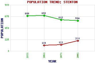
Stenton Classification and Statistics Settlement Type: village Population (1991): 200 (1971): 122 (1961): 114 (1881): 594 (1871): 612 (1861): 692 (1831): 686 Tourist Rating: Yes Text of Entry Updated: 19-APR-2011 Location Latitude: 55.9593°N Longitude: 2.607°W National Grid Reference: NT 622 741 A range of modern and historical maps are accessible through the map tab on the right of this page Get directions by entering the UK postcode of your location, home or hotel here eg. EH1 3YT Use the tabs on the right of this page to see other parts of this entry Related Entries There are 24 related entries. (1 Attraction, 1 Council Area, 1 Historical County, 1 Family, 8 Features, 1 Parish, 4 People and 7 Settlements) Names that are not linked do not currently contain any information. Attractions: Prestonkirk Parish Church Council Area: East Lothian Families: Sydserff Features: Archerfield House Deuchrie Dod Deuchrie Edge Eachil Rig Lothian Edge Pressmennan Loch Pressmennan Wood Whittingehame House Historical Counties: East Lothian Parishes: Stenton People: Arthur James Balfour(1st Earl Balfour of Whittingehame) William Burn John Hamilton(2nd Baron Belhaven and Stenton) John Hamilton(3rd Baron Belhaven and Stenton) Settlements: Biel Dunbar East Linton Garvald Luggate Luggate Burn Pitcox
There are 24 related entries. (1 Attraction, 1 Council Area, 1 Historical County, 1 Family, 8 Features, 1 Parish, 4 People and 7 Settlements)
Names that are not linked do not currently contain any information.
By using our site you agree to accept cookies, which help us serve you better