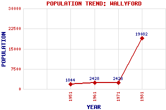
Wallyford Classification and Statistics Settlement Type: village Population (1981): 19082 (Combined with Musselburgh) (1971): 2428 (1961): 2428 (1951): 1844 Tourist Rating: No Text of Entry Updated: 19-APR-2011 Location Latitude: 55.9387°N Longitude: 3.0133°W National Grid Reference: NT 368 722 A range of modern and historical maps are accessible through the map tab on the right of this page Get directions by entering the UK postcode of your location, home or hotel here eg. EH1 3YT Use the tabs on the right of this page to see other parts of this entry Related Entries There are 21 related entries. (1 Attraction, 1 Council Area, 1 Historical County, 1 Event, 8 Features, 1 Parish, 3 People and 5 Settlements) Names that are not linked do not currently contain any information. Attractions: Pinkie Battlefield Council Area: East Lothian Events: Rough Wooing, The Features: Carberry Hill Drummore House East Coast Main Line Fa'side Castle Falside Hill Pinkie Braes Scarlett Park Wallyford Railway Station Historical Counties: Midlothian Parishes: Inveresk People: Rear Admiral Robert Aitchison Margaret Oliphant(Margaret Wilson) William (Willie) Park (Senior) Settlements: Dolphingstone Elphinstone Musselburgh Prestonpans Strawberry Corner
There are 21 related entries. (1 Attraction, 1 Council Area, 1 Historical County, 1 Event, 8 Features, 1 Parish, 3 People and 5 Settlements)
Names that are not linked do not currently contain any information.
By using our site you agree to accept cookies, which help us serve you better