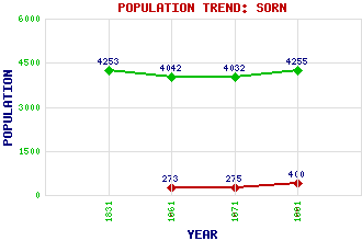
Sorn (Dalgain) Classification and Statistics Settlement Type: village Population (1991): 400 (1971): 275 (1961): 273 (1881): 4255 (1871): 4032 (1861): 4042 (1831): 4253 Tourist Rating: N/A Text of Entry Updated: 18-FEB-2004 Location Latitude: 55.5108°N Longitude: 4.2897°W National Grid Reference: NS 555 265 A range of modern and historical maps are accessible through the map tab on the right of this page Get directions by entering the UK postcode of your location, home or hotel here eg. EH1 3YT Use the tabs on the right of this page to see other parts of this entry Related Entries There are 18 related entries. (0 Attractions, 1 Council Area, 1 Historical County, 2 Families, 9 Features, 1 Parish, 1 Person and 3 Settlements) Names that are not linked do not currently contain any information. Council Area: East Ayrshire Families: Campbell Hamilton Features: Aird's Moss Auchenlongford Hill Ayr, River Blackside Blacksidend Hart Hill Little Hartmidden River Ayr Way Sorn Castle Historical Counties: Ayrshire Parishes: Sorn People: Alexander Peden Settlements: Auchinleck Glenlogan Mauchline
There are 18 related entries. (0 Attractions, 1 Council Area, 1 Historical County, 2 Families, 9 Features, 1 Parish, 1 Person and 3 Settlements)
Names that are not linked do not currently contain any information.
By using our site you agree to accept cookies, which help us serve you better