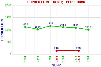
Closeburn Classification and Statistics Settlement Type: village Population (1971): 225 (1961): 218 (1881): 1512 (1871): 1612 (1861): 1651 (1851): 1732 (1841): 1530 (1831): 1680 Tourist Rating: N/A Text of Entry Updated: 04-APR-2017 Location Latitude: 55.2143°N Longitude: 3.7382°W National Grid Reference: NX 895 925 A range of modern and historical maps are accessible through the map tab on the right of this page Get directions by entering the UK postcode of your location, home or hotel here eg. EH1 3YT Use the tabs on the right of this page to see other parts of this entry Related Entries There are 23 related entries. (1 Attraction, 1 Council Area, 1 Historical County, 1 Family, 15 Features, 1 Parish, 0 People and 3 Settlements) Names that are not linked do not currently contain any information. Attractions: Museum of Fire Council Area: Dumfries and Galloway Families: Kirkpatrick Features: Auchencairn Height Closeburn Castle Dollard Hill Ettrick, Loch Glasgow South Western Line Glencorse Hill Great Hill Lamb Hill McMount Nith, River Nithsdale Watchman Hill White Hill Windy Hill Windyhill Rig Historical Counties: Dumfriesshire Parishes: Closeburn Settlements: Dumfries Park Shawsholm
There are 23 related entries. (1 Attraction, 1 Council Area, 1 Historical County, 1 Family, 15 Features, 1 Parish, 0 People and 3 Settlements)
Names that are not linked do not currently contain any information.
By using our site you agree to accept cookies, which help us serve you better