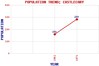
Castlecary Classification and Statistics Settlement Type: village Population (1971): 284 (1961): 158 Tourist Rating: Text of Entry Updated: 23-JAN-2021 Location Latitude: 55.9795°N Longitude: 3.9487°W National Grid Reference: NS 785 780 A range of modern and historical maps are accessible through the map tab on the right of this page Get directions by entering the UK postcode of your location, home or hotel here eg. EH1 3YT Use the tabs on the right of this page to see other parts of this entry Related Entries There are 20 related entries. (3 Attractions, 1 Council Area, 1 Historical County, 1 Event, 10 Features, 1 Parish, 0 People and 3 Settlements) Names that are not linked do not currently contain any information. Attractions: Antonine Wall, The Forth and Clyde Canal John Muir Way Council Area: North Lanarkshire Events: Castlecary Disaster Features: Bonny Water Castle Cary Castlecary Viaduct Cumbernauld Airport Cumbernauld Line Glasgow-Perth Line M80 Motorway Our Lady's High School Red Burn Wardpark Historical Counties: Dunbartonshire Parishes: Cumbernauld Settlements: Allandale Banknock Cumbernauld
There are 20 related entries. (3 Attractions, 1 Council Area, 1 Historical County, 1 Event, 10 Features, 1 Parish, 0 People and 3 Settlements)
Names that are not linked do not currently contain any information.
By using our site you agree to accept cookies, which help us serve you better