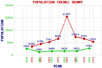
Denny Classification and Statistics Settlement Type: small town Population (2011): 7933 (2001): 9797 (1991): 11061 (1981): 23157(Combined with Banknock, Dennyloanhead, Dunipace, Haggs and Stoneywood) (1971): 9841 (1961): 7760 (1951): 6756 (1901): 5158(Police Burgh) (1881): 4081 (1871): 2433 (1861): 2428 (1851): 2446 (1841): 1881 (1831): 3843 Tourist Rating: No Text of Entry Updated: 16-DEC-2008 Location Latitude: 56.0224°N Longitude: 3.9075°W National Grid Reference: NS 812 827 A range of modern and historical maps are accessible through the map tab on the right of this page Get directions by entering the UK postcode of your location, home or hotel here eg. EH1 3YT References and Further Reading Jaques, Richard (2001) Falkirk and District: An Illustrated Architectural Guide. The Rutland Press, Edinburgh Use the tabs on the right of this page to see other parts of this entry Related Entries There are 29 related entries. (1 Attraction, 1 Council Area, 1 Historical County, 10 Features, 1 Parish, 3 People and 12 Settlements) Names that are not linked do not currently contain any information. Attractions: Tor Wood Council Area: Falkirk Features: Carron Valley Reservoir Carron, River Denny High School Drumbowie Reservoir Earl's Burn Larbert Junction Little Denny Reservoir Loch Coulter Reservoir Myot Hill Tarff, Glen Historical Counties: Stirlingshire Parishes: Denny People: Campbell Christie Bill Findlay Sadie McLellan Settlements: Allandale Banknock Bonnybridge Carron Bridge Dennyloanhead Dunipace Fankerton Larbert Muir, Head of Stenhousemuir Stirling Stoneywood
There are 29 related entries. (1 Attraction, 1 Council Area, 1 Historical County, 10 Features, 1 Parish, 3 People and 12 Settlements)
Names that are not linked do not currently contain any information.
By using our site you agree to accept cookies, which help us serve you better