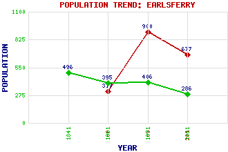
Earlsferry Classification and Statistics Settlement Type: village Population (2011): 677 (Combined with Elie) (1991): 900 (1901): 317(Royal Burgh) (1881): 286 (1871): 406 (1861): 395 (1841): 496 Tourist Rating: Text of Entry Updated: 04-JUN-2006 Location Latitude: 56.1879°N Longitude: 2.8361°W National Grid Reference: NT 482 998 A range of modern and historical maps are accessible through the map tab on the right of this page Get directions by entering the UK postcode of your location, home or hotel here eg. EH1 3YT Use the tabs on the right of this page to see other parts of this entry Related Entries There are 16 related entries. (1 Attraction, 1 Council Area, 1 Historical County, 7 Features, 1 Parish, 2 People and 3 Settlements) Names that are not linked do not currently contain any information. Attractions: Fife Coastal Path Council Area: Fife Features: East Neuk of Fife East Vows Elie Golf Course Forth, Firth of Lothian Ruddons Point Shell Bay Historical Counties: Fife Parishes: Elie People: Macbeth(Mormaer of Moray) Archibald (Archie) Simpson Settlements: Elie Macduff North Berwick
There are 16 related entries. (1 Attraction, 1 Council Area, 1 Historical County, 7 Features, 1 Parish, 2 People and 3 Settlements)
Names that are not linked do not currently contain any information.
By using our site you agree to accept cookies, which help us serve you better