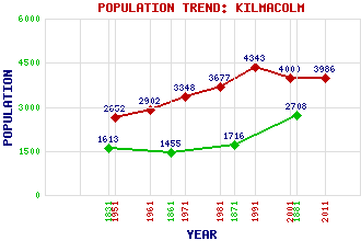
Kilmacolm Classification and Statistics Settlement Type: village Population (2011): 3986 (2001): 4000 (1991): 4343 (1981): 3677 (1971): 3348 (1961): 2902 (1951): 2652 (1881): 2708 (1871): 1716 (1861): 1455 (1831): 1613 Tourist Rating: Text of Entry Updated: 09-JAN-2007 Location Latitude: 55.8941°N Longitude: 4.6274°W National Grid Reference: NS 358 699 A range of modern and historical maps are accessible through the map tab on the right of this page Get directions by entering the UK postcode of your location, home or hotel here eg. EH1 3YT Use the tabs on the right of this page to see other parts of this entry Related Entries There are 24 related entries. (0 Attractions, 1 Council Area, 1 Historical County, 10 Features, 1 Parish, 6 People and 5 Settlements) Names that are not linked do not currently contain any information. Council Area: Inverclyde Features: Balrossie School Duchal Grouse Railway Gryfe Water Gryfe, River Gryfe, Strath Kaim Dam Kilmacolm Golf Club Knapps Loch Whinny Hill Historical Counties: Renfrewshire Parishes: Kilmacolm People: Donald Bain Dallas Campbell Sir Alistair Dunnett Mairi Hedderwick(Mairi Crawford Lindsay) Charles Rennie Mackintosh Sir Eric Yarrow Settlements: Auchenbothie Auchenfoyle Cairncurran Greenock Quarrier's Village
There are 24 related entries. (0 Attractions, 1 Council Area, 1 Historical County, 10 Features, 1 Parish, 6 People and 5 Settlements)
Names that are not linked do not currently contain any information.
By using our site you agree to accept cookies, which help us serve you better