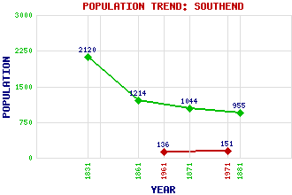
Southend Classification and Statistics Settlement Type: hamlet Population (1971): 151 (1961): 136 (1881): 955 (1871): 1044 (1861): 1214 (1831): 2120 Tourist Rating: Yes Text of Entry Updated: 08-SEP-2006 Location Latitude: 55.3162°N Longitude: 5.6389°W National Grid Reference: NR 692 085 A range of modern and historical maps are accessible through the map tab on the right of this page Get directions by entering the UK postcode of your location, home or hotel here eg. EH1 3YT Use the tabs on the right of this page to see other parts of this entry Related Entries There are 23 related entries. (6 Attractions, 1 Council Area, 1 Historical County, 8 Features, 1 Parish, 2 People and 4 Settlements) Names that are not linked do not currently contain any information. Attractions: Dunaverty Bay Dunaverty Castle Keil Cave Keil Point St Columba's Chapel St Columba's Footprints Council Area: Argyll and Bute Features: Cnoc Moy Cnoc Odhar Conie Glen Conie Water Dunaverty Golf Club Dunaverty Rock Kilchattan Hill Kintyre Historical Counties: Argyllshire Parishes: Southend People: Saint Columba(St. Columba or Saint Colum Cille) Belle Robertson Settlements: Campbeltown Dunaverty Kilchattan Macharioch
There are 23 related entries. (6 Attractions, 1 Council Area, 1 Historical County, 8 Features, 1 Parish, 2 People and 4 Settlements)
Names that are not linked do not currently contain any information.
By using our site you agree to accept cookies, which help us serve you better