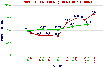
Newton Stewart Classification and Statistics Settlement Type: village Population (2011): 4092 (2001): 3573 (1991): 3673 (1981): 3247(Combined with Creebridge and Minnigaff) (1971): 1883 (1961): 1981 (1951): 1997 (1901): 2204(Police Burgh) (1881): 3070 (1871): 2873 (1861): 2535 (1851): 2599 (1841): 2432 Tourist Rating: Text of Entry Updated: 01-NOV-2020 Location Latitude: 54.956°N Longitude: 4.4846°W National Grid Reference: NX 410 652 A range of modern and historical maps are accessible through the map tab on the right of this page Get directions by entering the UK postcode of your location, home or hotel here eg. EH1 3YT Use the tabs on the right of this page to see other parts of this entry Related Entries There are 176 related entries. (5 Attractions, 1 Council Area, 1 Historical County, 95 Features, 36 Parishes, 7 People and 31 Settlements) Names that are not linked do not currently contain any information. Attractions: Garlies Castle Glentrool Forest Merrick Leisure Centre Newton Stewart Museum Wild Goat Park Council Area: Dumfries and Galloway Features: Ardachie Fell Artfield Fell Wind Farm Auchlannochy Hill Baltorrens Bank Hill Barbae Barbuchany Bargaly Barneam Hill Barnkirk Barnkirk Hill Barr Hill Barraer Fell Barskeoch Benailsa Benera Bennan Hill Bishop Burn Black Burn Black Hill Black Loch Black Loch Bladnoch, River Bridge of Cree Bruntis Loch Cairn Hill Cairnsmore of Fleet Castle Douglas Hospital Castle Stewart Cawvis Hill Challoch Hill Coldside Hill Corwar Hill Craigeach Fell Craigenroy Craignell Craigree Cree, Loch of Culbratten Hill Culvennan Fell Cut Island Dernaglar Loch Douglas Ewart High School Drumgowan Drumnawantie Hill Drumterlie Hill Drumwhirns Dumfries and Galloway College Eldrig Fell Eldrig Hill Eldrig, Loch Fleet, Fell of Fyntalloch, Loch of Galloway Garlick Hill Garwachie Loch Glassoch Fell Glenamour Loch Glengarren Loch Graddoch Burn Kiln Hill Kirroughtree Forest Knockhammy Knockinderry Hill Lamachan Hill Larg Hill Larg Hill Loch of the Lowes Strand Lowes, Loch of the Maberry, Loch Merton Hall Middle, Loch Millfore Millgrane Hill Minnoch, Water of Mulloch Hill Neldricken, Loch Newton Stewart Golf Club Ochiltree, Hill of Ochiltree, Loch Palnure Burn Penkiln Burn Penninghame Forest Penninghame House Queen's Way, The Rolland Hill Round Fell Silver Rig Loch South Barnkirk Hill Strone of Auchinleck Talnotry, Fell of Trool, Glen Trool, Loch White Hill Wigtownshire Historical Counties: Wigtownshire Parishes: Anwoth Colmonell Girthon Girthon Glasserton Glasserton Inch Inch Kells Kells Kelton Kirkcowan Kirkcowan Kirkcudbright Kirkinner Kirkinner Kirkmabreck Kirkmabreck Kirkmaiden Minnigaff Minnigaff Mochrum Mochrum New Luce Old Luce Penninghame Penninghame Portpatrick Sorbie Sorbie Stoneykirk Stranraer Whithorn Whithorn Wigtown Wigtown People: William Alexander Agnew David Dale Sir William Douglas (John David) Ruari McDowall Hardie McLean Sir James Alexander Mirrlees John Rennie Colonel Patrick Stewart Settlements: Baltersan Bargrennan Barlae Barraer Blackcraig Calgow Causeway End Challoch Clachaneasy Corwar House Craigdews Creebank Creebridge Creetown Drumterlie Glen Glenrazie Glentrool Village Glenvernoch Kelton Kirkcowan Kirriereoch Knowe Mid Kelton Minnigaff Palnure Polbae Shennanton Stranraer Talnotry Wigtown
There are 176 related entries. (5 Attractions, 1 Council Area, 1 Historical County, 95 Features, 36 Parishes, 7 People and 31 Settlements)
Names that are not linked do not currently contain any information.
By using our site you agree to accept cookies, which help us serve you better