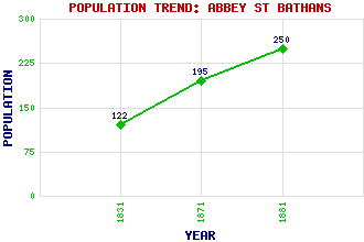
Abbey St Bathans Classification and Statistics Settlement Type: village Population (1881): 250 (1871): 195 (1831): 122 Tourist Rating: No Text of Entry Updated: 21-JAN-2010 Location Latitude: 55.8497°N Longitude: 2.3816°W National Grid Reference: NT 762 619 A range of modern and historical maps are accessible through the map tab on the right of this page Get directions by entering the UK postcode of your location, home or hotel here eg. EH1 3YT Use the tabs on the right of this page to see other parts of this entry Related Entries There are 15 related entries. (3 Attractions, 1 Council Area, 1 Historical County, 7 Features, 1 Parish, 0 People and 2 Settlements) Names that are not linked do not currently contain any information. Attractions: Edin's Hall Sir Walter Scott Way Southern Upland Way Council Area: Scottish Borders Features: Abbey Hill Cockburn Law Corse Law Heart Law Laughing Law Monynut Water Whiteadder Water Historical Counties: Berwickshire Parishes: Abbey St Bathans Settlements: Duns Stow
There are 15 related entries. (3 Attractions, 1 Council Area, 1 Historical County, 7 Features, 1 Parish, 0 People and 2 Settlements)
Names that are not linked do not currently contain any information.
By using our site you agree to accept cookies, which help us serve you better