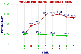
Inverkeithing Classification and Statistics Settlement Type: small town Population (2011): 5280 (2001): 5412 (1991): 6001 (1981): 5772 (1971): 5861 (1961): 4068 (1951): 3695 (1901): 1909(Parliamentary Burgh) (1881): 1653 (1871): 1763 (1861): 1929 (1831): 2020 Tourist Rating: Text of Entry Updated: 25-JUL-2013 Location Latitude: 56.0319°N Longitude: 3.396°W National Grid Reference: NT 131 830 A range of modern and historical maps are accessible through the map tab on the right of this page Get directions by entering the UK postcode of your location, home or hotel here eg. EH1 3YT Use the tabs on the right of this page to see other parts of this entry Related Entries There are 45 related entries. (8 Attractions, 1 Council Area, 1 Historical County, 1 Event, 1 Family, 9 Features, 1 Parish, 10 People and 13 Settlements) Names that are not linked do not currently contain any information. Attractions: Aberdour Castle Ferry Hills Fife Coastal Path Glenfarg North Tunnel Glenfarg South Tunnel Inverkeithing Museum Rosyth Castle Scottish Lime Centre, The Council Area: Fife Events: Battle of Inverkeithing Families: Henderson Features: Donibristle East Coast Main Line Forth, Firth of Inner Bay Inverkeithing Bay Inverkeithing High School Inverkeithing Railway Station Inverkeithing Tunnel Keithing Burn Historical Counties: Fife Parishes: Inverkeithing People: Gnaeus Julius Agricola William Ewart Gladstone Sir Samuel Greig Stephen Hendry David Hutcheson David Livingstone Dr. Robert Moffat Robert James Naismith King Robert III King William I(The Lion) Settlements: Aberdour Dalgety Bay Dunfermline Halbeath Hillend Jamestown Masterton Mawcarse North Queensferry Rosyth St David's Harbour Torryburn Townhill
There are 45 related entries. (8 Attractions, 1 Council Area, 1 Historical County, 1 Event, 1 Family, 9 Features, 1 Parish, 10 People and 13 Settlements)
Names that are not linked do not currently contain any information.
By using our site you agree to accept cookies, which help us serve you better