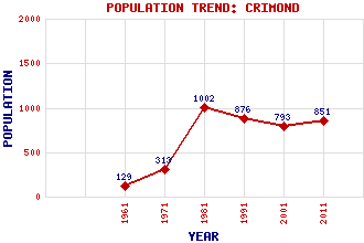
Crimond Classification and Statistics Settlement Type: village Population (2011): 851 (2001): 793 (1991): 876 (1981): 1002 (1971): 313 (1961): 129 Tourist Rating: No Text of Entry Updated: 11-JUL-2019 Location Latitude: 57.6007°N Longitude: 1.9146°W National Grid Reference: NK 052 567 A range of modern and historical maps are accessible through the map tab on the right of this page Get directions by entering the UK postcode of your location, home or hotel here eg. EH1 3YT Use the tabs on the right of this page to see other parts of this entry Related Entries There are 15 related entries. (4 Attractions, 1 Council Area, 1 Historical County, 5 Features, 1 Parish, 2 People and 1 Settlement) Names that are not linked do not currently contain any information. Attractions: Crimond Parish Church Crimond Raceway DHFCS Crimond Jim Clark Motorsport Museum Council Area: Aberdeenshire Features: Buchan Crimond Medical and Community Hub RAF Aird Uig St Fergus Moss Wind Farm Strathbeg, Loch of Historical Counties: Aberdeenshire Parishes: Crimond People: David Grant Jessie Seymour Irvine Settlements: Peterhead
There are 15 related entries. (4 Attractions, 1 Council Area, 1 Historical County, 5 Features, 1 Parish, 2 People and 1 Settlement)
Names that are not linked do not currently contain any information.
By using our site you agree to accept cookies, which help us serve you better