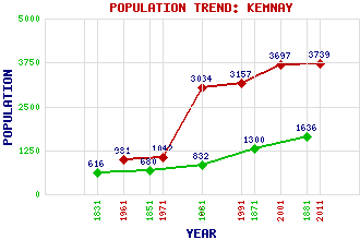
Kemnay Classification and Statistics Settlement Type: village Population (2011): 3739 (2001): 3697 (1991): 3157 (1981): 3034 (1971): 1042 (1961): 981 (1881): 1636 (1871): 1300 (1861): 832 (1851): 680 (1831): 616 Tourist Rating: N/A Text of Entry Updated: 24-AUG-2009 Location Latitude: 57.233°N Longitude: 2.4522°W National Grid Reference: NJ 728 159 A range of modern and historical maps are accessible through the map tab on the right of this page Get directions by entering the UK postcode of your location, home or hotel here eg. EH1 3YT Use the tabs on the right of this page to see other parts of this entry Related Entries There are 21 related entries. (5 Attractions, 1 Council Area, 1 Historical County, 7 Features, 1 Parish, 3 People and 3 Settlements) Names that are not linked do not currently contain any information. Attractions: Alford Valley Railway Forth Bridge His Majesty's Theatre Marischal College Scottish Parliament Council Area: Aberdeenshire Features: Collydean Don, River Fetternear Kemnay Academy Kemnay Golf Club Lang Stane o' Craigearn St Mark's Church Historical Counties: Aberdeenshire Parishes: Chapel of Garioch People: John Fyfe Paul Lawrie James (Jim) McColl Settlements: Aberdeen Aquhorthies Craigearn
There are 21 related entries. (5 Attractions, 1 Council Area, 1 Historical County, 7 Features, 1 Parish, 3 People and 3 Settlements)
Names that are not linked do not currently contain any information.
By using our site you agree to accept cookies, which help us serve you better