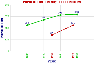
Fettercairn Classification and Statistics Settlement Type: village Population (1971): 281 (1961): 174 (1881): 398 (1871): 391 (1861): 339 (1841): 280 Tourist Rating: N/A Text of Entry Updated: 07-MAY-2008 Location Latitude: 56.8516°N Longitude: 2.5754°W National Grid Reference: NO 650 735 A range of modern and historical maps are accessible through the map tab on the right of this page Get directions by entering the UK postcode of your location, home or hotel here eg. EH1 3YT Use the tabs on the right of this page to see other parts of this entry Related Entries There are 21 related entries. (5 Attractions, 1 Council Area, 1 Historical County, 7 Features, 1 Parish, 2 People and 4 Settlements) Names that are not linked do not currently contain any information. Attractions: Deeside Fasque Fettercairn Distillery Victorian Arch Victorian Heritage Trail Council Area: Aberdeenshire Features: Cairn o' Mount Dowrie Burn Fingray, Hill of Glensaugh Goyle Hill Hound Hillock Kincardine Castle Historical Counties: Kincardineshire Parishes: Fettercairn People: Sir John Gladstone Queen Victoria Settlements: Banchory Kincardine Laurencekirk Strachan
There are 21 related entries. (5 Attractions, 1 Council Area, 1 Historical County, 7 Features, 1 Parish, 2 People and 4 Settlements)
Names that are not linked do not currently contain any information.
By using our site you agree to accept cookies, which help us serve you better