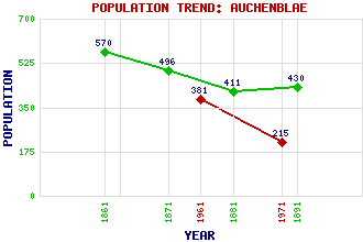
Auchenblae (Auchinblae) Classification and Statistics Settlement Type: village Population (1971): 215 (1961): 381 (1891): 430 (1881): 411 (1871): 496 (1861): 570 Tourist Rating: No Text of Entry Updated: 27-JUL-2009 Location Latitude: 56.8979°N Longitude: 2.4497°W National Grid Reference: NO 727 786 A range of modern and historical maps are accessible through the map tab on the right of this page Get directions by entering the UK postcode of your location, home or hotel here eg. EH1 3YT Use the tabs on the right of this page to see other parts of this entry Related Entries There are 17 related entries. (0 Attractions, 1 Council Area, 1 Historical County, 9 Features, 1 Parish, 2 People and 3 Settlements) Names that are not linked do not currently contain any information. Council Area: Aberdeenshire Features: Auchenblae Golf Club Burnieshag, Hill of Court Stane Herscha Hill Howe of the Mearns Luther Water Monboddo Smart's Cairn Strathfinella Hill Historical Counties: Kincardineshire Parishes: Fordoun People: David Lyall George Wishart Settlements: Fordoun Glenbervie Laurencekirk
There are 17 related entries. (0 Attractions, 1 Council Area, 1 Historical County, 9 Features, 1 Parish, 2 People and 3 Settlements)
Names that are not linked do not currently contain any information.
By using our site you agree to accept cookies, which help us serve you better