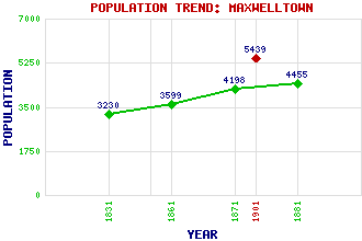
Maxwelltown Classification and Statistics Settlement Type: suburb Population (1901): 5439 (Parliamentary Burgh) (1881): 4455 (1871): 4198 (1861): 3599 (1831): 3230 Tourist Rating: N/A Text of Entry Updated: 30-MAY-2010 Location Latitude: 55.0676°N Longitude: 3.6207°W National Grid Reference: NX 966 760 A range of modern and historical maps are accessible through the map tab on the right of this page Get directions by entering the UK postcode of your location, home or hotel here eg. EH1 3YT Use the tabs on the right of this page to see other parts of this entry Related Entries There are 15 related entries. (5 Attractions, 1 Council Area, 1 Historical County, 3 Features, 1 Parish, 3 People and 1 Settlement) Names that are not linked do not currently contain any information. Attractions: Devorguilla's Bridge Dumfries Ice Bowl Dumfries Museum and Camera Obscura Palmerston Park Suspension Bridge Council Area: Dumfries and Galloway Features: New Bridge Nith, River St Michael's Bridge Historical Counties: Dumfriesshire Parishes: Troqueer People: Alexander James Adie Christian (Chris) Jane Fergusson(Christian Stark; Christina Stark) William McDowall Settlements: Dumfries
There are 15 related entries. (5 Attractions, 1 Council Area, 1 Historical County, 3 Features, 1 Parish, 3 People and 1 Settlement)
Names that are not linked do not currently contain any information.
By using our site you agree to accept cookies, which help us serve you better