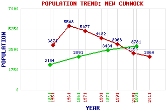
New Cumnock Classification and Statistics Settlement Type: village Population (2011): 2860 (2001): 3165 (1991): 3968 (1981): 4482 (1971): 5077 (1961): 5508 (1951): 3871 (1881): 3781 (1871): 3434 (1861): 2891 (1831): 2184 Tourist Rating: Text of Entry Updated: 10-FEB-2016 Location Latitude: 55.3906°N Longitude: 4.1786°W National Grid Reference: NS 621 129 A range of modern and historical maps are accessible through the map tab on the right of this page Get directions by entering the UK postcode of your location, home or hotel here eg. EH1 3YT Use the tabs on the right of this page to see other parts of this entry Related Entries There are 29 related entries. (0 Attractions, 1 Council Area, 1 Historical County, 15 Features, 1 Parish, 1 Person and 10 Settlements) Names that are not linked do not currently contain any information. Council Area: East Ayrshire Features: Afton Water Alhang Alwhat Blackcraig Hill Clocklowie Hill Corsencon Hill Dryfeston Hill Enoch Hill Euchan Water Hare Hill Wind Farm Lethans Hill New Cumnock Golf Club New Cumnock Railway Station Nith, River Windy Standard Wind Farm Historical Counties: Ayrshire Parishes: New Cumnock People: Sir Thomas (Tom) Blane Hunter Settlements: Afton Bridgend Bankglen Benston Clocklowie Cumnock Lochhill Marchburn Old Coalburn Pathhead Rigg
There are 29 related entries. (0 Attractions, 1 Council Area, 1 Historical County, 15 Features, 1 Parish, 1 Person and 10 Settlements)
Names that are not linked do not currently contain any information.
By using our site you agree to accept cookies, which help us serve you better